EGU Short course code (part 2)
The second part of our EGU Short Course on Analyzing transient landscapes using TopoToolbox focused on the analysis of drainage divides using @DIVIDEobj, a numerical class to store, analyze and visualize drainage divides. The data for the course can be downloaded here. Below, you’ll find Dirk’s commented code that shows how to analyze drainage divides in the Parachute Creek.
Read the rest of this entry »EGU Short course code (part 1)
The first part of our EGU Short Course on Analyzing transient landscapes using TopoToolbox focused on the analysis of knickpoints using the numerical object PPS. The data can be downloaded here. Below, you’ll find the commented code that shows how to analyze and model the distribution of knickpoints in the Parachute Creek using point pattern analysis.
Read the rest of this entry »Data for Short Course
If you are participating at the EGU Short Course on Monday, 16-18 CET, you may consider to download the data.
Download data
Make also sure to download the latest development version of TopoToolbox which you find here: https://github.com/wschwanghart/topotoolbox (direct download).
See you at the course!
TopoToolbox Short-Course at the EGU2024

You are cordially invited to participate in our upcoming short course on the analysis of transient landscapes using TopoToolbox, to be held at the European Geosciences Union (EGU) General Assembly 2024, Mon, 15 Apr, 16:15–18:00 (CEST), Room -2.61/62. If you are attending virtually, you’ll also be able to follow the course with Zoom. Here’s the session description:
Read the rest of this entry »Snowy Big Tujunga
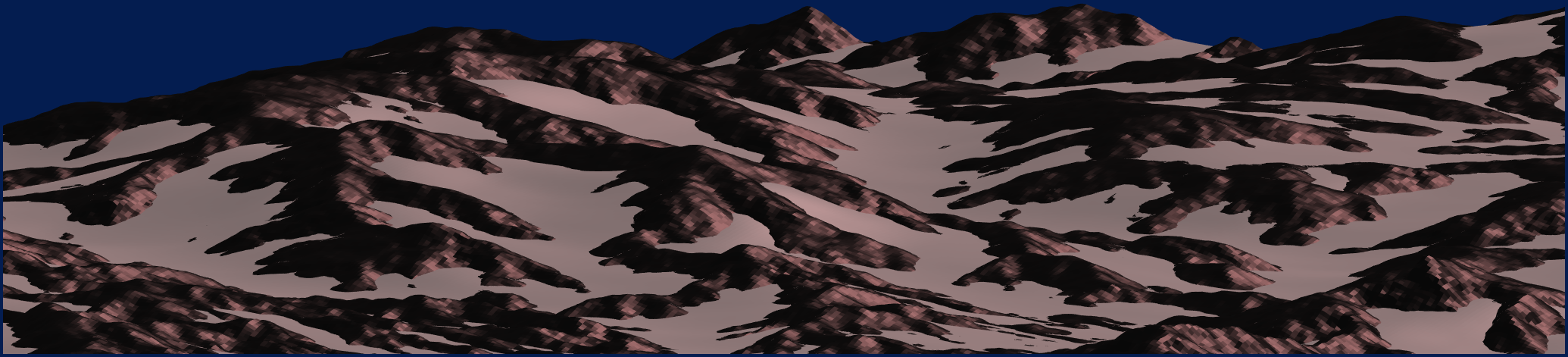
Snow is not so common in the Big Tujunga catchment, the DEM of which is the all-time favorite sample data that ships with TopoToolbox. But we can quite easily render the DEM as if it was a periglacial landscape covered by extensive snow patches. Inspired by a recent post by Adam Danz on random surfaces and a beautiful example by Tim, I wrote a short script that creates an animation of snowy Big Tujunga. Uncomment the lines that call the function gif to create a gif image. Looking forward to comments with modifications to my code that create nicer renderings.
Read the rest of this entry »Two new talks online
I recently had the chance to give presentations about my work. One of these talks was part of the Computational Geomorphology workshop organized by Fiona Clubb and Stuart Grieve. The key notes are now available on youtube. My talk addressed the past and future development of TopoToolbox and best practices in topographic analysis.
A second talk was part of a workshop at the IIT Roorkee and followed an excursion to Uttarakhand and the Indian Himalaya. In this talk, Jürgen Mey and I talk about our recent research about road-side landslides in Uttarakhand and how these can be modelled using point-pattern analysis on linear networks. Unfortunately, much of the code is not shown during the video but you can download it here.
Have fun watching.
Join us and take TopoToolbox to the next level
TopoToolbox has now been around for more than a decade. Yet, there are many new developments needed to take TopoToolbox to the next level. This requires a lot of work, and thus we are happy to announce that the German Research Foundation (DFG) granted us a project that enables us to hire a PostDoc/Research Software Engineer to support our team.
Please check the official job announcement here (german version).
We are seeking a skilled and motivated PostDoc/Research Software Engineer to join our team for the DFG-funded project “TopoToolbox 3 – improving the quality and reuse of a research software for terrain analysis”. Our team, that’s Wolfgang Schwanghart, Dirk Scherler and Anna-Lena Lamprecht. You will contribute to the further development of TopoToolbox, a versatile and widely used open-source toolbox for digital elevation model (DEM) analysis. The aims of the project are i) to improve the usability and accessibility of TopoToolbox by a broad academic research community, ii) to improve the quality assurance in the software’s development process, and iii) to increase the involvement of the research community in the ongoing development of TopoToolbox.
As a Research Software Engineer on the project, you will play a crucial role in expanding TopoToolbox’s functionality, enhancing its sustainability and usability, and ensuring it remains a valuable resource for the geoscientific and environmental research community. You will work closely with an engaged team of researchers from the geosciences and computational sciences, utilizing your expertise in high-level programming languages such as Python, MATLAB, R, and low-level languages like C or C++. This position offers an excellent opportunity to kickstart a career as a Research Software Engineer in a geoscientific and environmental setting. This position is fixed-term for the duration of the project (24 months) with the potential for extension based on performance and funding availability.
Please find additional information (requirements, benefits, how to apply) here. We are looking forward to receiving your application! If you have questions, don’t hesitate to contact me.
TopoToolbox Short Course at the IIT Roorkee
Today, Oct 18 2023, Jürgen Mey and I will give a short course on TopoToolbox at the IIT Roorkee/India. The course follows a field trip with students to the Indian Himalayas within the project Co-PREPARE funded by the University Grant Commission (UGC) and German Academic Exchange Service (DAAD) through the Indo German Partnership in Higher Education (IGP 2020-2024).
In this course, we will offer an introduction to analyzing point patterns on river networks, thus linking digital terrain analysis with spatial statistics. The example, which we’ll use, will be about landslides along the NH-7, an important road linking Rishikesh and Joshimath. The example script and all the data can be downloaded (PW: IIT_Roorkee_course). The code used to offer a brief insight into TopoToolbox is shown below.
Read the rest of this entry »Estimating the volume of the South Lhonak Lake outburst
The Oct 4, 2023, flashflood in Sikkim was caused by the outburst of South Lhonak Lake. In my previous post, I showed how to derive some basic metrics about the outburst path and its length to the destroyed Chungthang dam which is an integral part of the Teesta III 1200 Mw hydropower project. In the meantime, Planet satellite imagery before and after the event offer insights into what happened at the lake itself. A number of evidences propose that the lake may have burst due to a failure of the moraine straddling the lake in the northern part.
To simulate such floods requires good estimates of the outflow volume and while we are still waiting for measurements taken in the field, I will try to come up with an estimate based on topographic analysis of the High Mountain Asia (HMA) 8-m DEM together with Planet imagery taken before and after the disaster. The following post will detail the steps that I have taken in GIS and TopoToolbox, and will explain the assumptions behind the analysis. For those who do not want to read the whole thing, here’s the result of the analysis: The outburst volume is 41.4 Mio m3, which equals 16544 Olympic size swimming pools.
Read the rest of this entry »Basic topographic metrics about the South Lhonak Lake outburst and the Chungthang Dam disaster
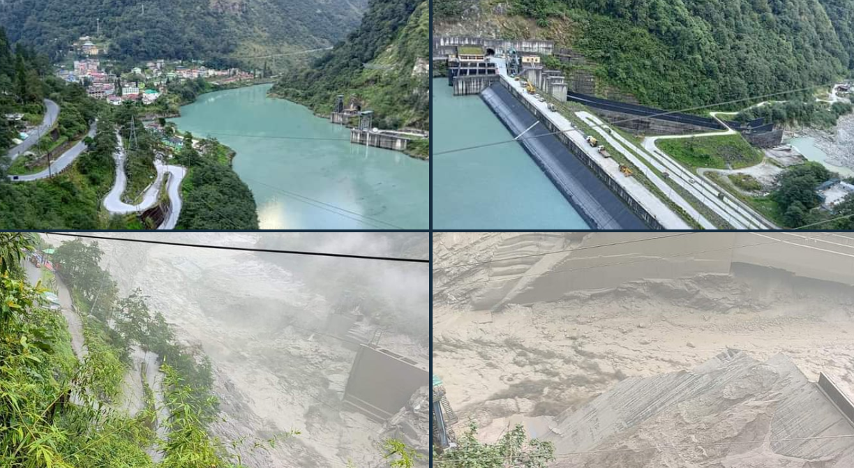
The river Teesta in the Indian Himalayan state Sikkim experienced severe flooding today. At the time of writing, at least five people died and 23 Indian Army troops are still missing. Moreover, Chungthang Dam, a 330 MW hydropower project has been severely damaged. The cause of the damage is a flash flood, likely triggered or amplified by the outburst of the glacial lake South Lhonak. This is not the first hydropower incident related to GLOFs. Thus, the GLOF and its inflicted damages once again exemplify the exposure of Himalayan hydropower to glacial hazards (Schwanghart et al., 2016).