new paper out
Limits to hydropower expansion in the Himalayas
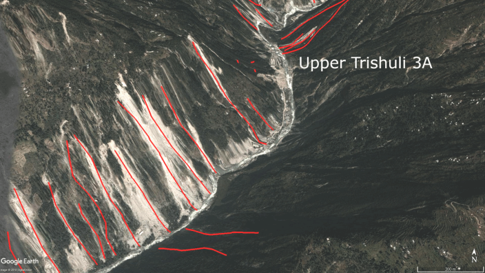
The 2015 Gorkha earthquake in Nepal caused severe losses in the hydropower sector. The country temporarily lost ~20% of its hydropower capacity, and >30 hydropower projects were damaged. In our paper that was just published in Geophysical Research Letters, we show that the projects hit hardest were those that were affected by earthquake‐triggered landslides. These projects are located along very steep rivers with towering sidewalls that are prone to become unstable during strong seismic ground shaking. A statistical classification based on a topographic metric that expresses river steepness and earthquake ground acceleration is able to approximately predict hydropower damage during future earthquakes, based on successful testing of past cases. Thus, our model enables us to estimate earthquake damages to hydropower projects in other parts of the Himalayas. We find that >10% of the Himalayan drainage network may be unsuitable for hydropower infrastructure given high probabilities of high earthquake damages.
Of course, we conducted the analysis primarily using TopoToolbox. A few functions that we used and partly developed for the purpose of our analysis are
- STREAMobj/chitransform
- STREAMobj/mchi
- STREAMobj/smooth
- STREAMobj/hillslopearea
References
Schwanghart, W., Ryan, M., Korup, O., 2018. Topographic and seismic constraints on the vulnerability of Himalayan hydropower. Geophysical Research Letters, in press. [DOI: 10.1029/2018GL079173]
see also Nature News article by Jane Qiu, 2018. Landslides pose threat to Himalayan hydropower dream. [DOI: 10.1038/d41586-018-06212-8]
Paper out now: Bumps in river profiles

Our paper on uncertainty quantification and smoothing of longitudinal river profiles has now been published in Earth Surface Dynamics. The paper describes a new approach to hydrologically correct and smooth profiles using quantile regression. Smoothing is based on curvature regularization with the constraint that elevation must decrease with increasing flow distance. We thus refer to this technique as constrained regularized smoothing (CRS). We compare CRS-derived profiles to profiles obtained from the common methods of filling and carving, and show that CRS outperforms these methods in terms of accuracy and precision.
Check out the new TopoToolbox functions that accompany the paper:
- STREAMobj/crs
- STREAMobj/crslin
- STREAMobj/crsapp
- STREAMobj/smooth
- STREAMobj/quantcarve
- FLOWobj/quantcarve
Applications of these functions were already described in the posts on An alternative to along-river swath profiles, Steepness derived from smoothed river profiles, Smooth operator….
References
Schwanghart, W., Scherler, D., 2017. Bumps in river profiles: uncertainty assessment and smoothing using quantile regression techniques. Earth Surface Dynamics, 5, 821-839. [DOI: 10.5194/esurf-5-821-2017]
Valley-fills as Himalayan Earthquake proxies
The Himalayan history is rich with a sequence of destructive earthquakes. In the last century, ground-shaking, collapsing houses, and landslides in the wake of earthquakes killed tens of thousand of people, wreaking havoc to the Himalayan nations. The 2015 Gorkha Earthquake was the latest in a series of severe earthquakes to hit Nepal.
Seismic hazard analysis in the Himalayas is based on few instrumental records and a paleoseismic record extending back ~1000 years. Paleoseismology largely relies on rupture histories derived from fault trenches, written accounts, and liquefaction features. Other records derived from e.g. lake sediments are scarce.
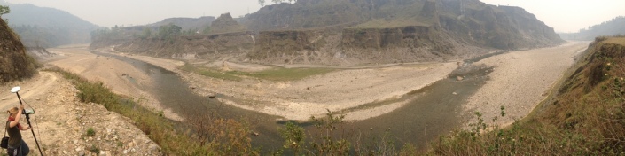
In a now published paper in Quaternary Science Reviews, Amelie Stolle et al. documents our research in the Pokhara Valley in Nepal. The valley was massively and repeatedly aggraded by several cubic kilometers of debris in the wake of medieval earthquakes in the region. The paper extends on our 2016 paper in Science, offering new radiocarbon dates and detailing the sedimentology of the infills. Based on our findings, we argue that valley fills in the Himalayas may offer substantial additional evidence for past earthquakes subsidy to the current portfolio of paleoseismological records.
References
Stolle, A., Bernhardt, A., Schwanghart, W., Hoelzmann, P., Adhikari, B.R., Fort, M., Korup, O., 2017. Catastrophic valley fills record large Himalayan earthquakes, Pokhara, Nepal. Quaternary Science Reviews, 177, 88-103. [DOI: 10.1016/j.quascirev.2017.10.015]. << free link to paper until December 26, 2017 >>
Sensitivity analysis of a highly parameterized landscape evolution model
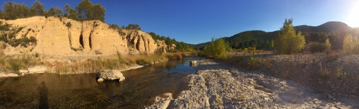
Today, I came back from an excellent workshop (organized by Darrel Maddy) in Spain focussing on the late Quaternary development of the Bergantes catchment. Located in an extremely beautiful landscape, this catchment features numerous fluvial terraces that were extensively studied and dated by Mark Macklin and Paul Brewer together with four PhD students between 2005 and 2009. A solid chronology together with high resolution terrain and climate data provide the benchmark data against we will test numerical landscape evolution models (LEM).
Assessing the capabilities of LEMs to reconstruct real landscapes, however, involves several challenges among which high parametrization is a severe one. Thus, in order to get a grip on the uncertainty and sensitivity of LEMs, Chris Skinner from the University of Hull led a study in which we assessed the parameter space of CAESAR-Lisflood and its effects on several output metrics derived from hundreds of simulations.
This study has now been accepted for discussion in the journal Geoscientific Model Development and can be accessed here.
References
Skinner, C. J., Coulthard, T. J., Schwanghart, W., Van De Wiel, M. J., and Hancock, G. (2017): Global Sensitivity Analysis of Parameter Uncertainty in Landscape Evolution Models, Geosci. Model Dev. Discuss., in review. [DOI: 10.5194/gmd-2017-236]
Smooth operator…

No, this post is not about my favorite interpretation of this song by Senor Coconut. Its about our latest discussion paper submitted to ESURF in which Dirk and I introduce a novel way to smooth river profiles. We show that DEMs in valley bottoms are characterized by errors with positively-skewed distributions and are often biased to higher values. These errors are more pronounced in high topographic relief, thus limiting our ability to interpret profiles. We also assess uncertainties of profiles derived from different globally available DEMs and find that the ALOS World 3D 30 m (AW3D30) DEM outperforms other DEMs in terms of precision and accuracy.
The manuscript comes with a set of functions that are now part of TopoToolbox and that I will cover in more detail in the following weeks. Here is a quick overview:
STREAMobj/smooth
STREAMobj/quantcarve
STREAMobj/crs
STREAMobj/crslin
STREAMobj/crsapp
and
FLOWobj/quantcarve
Have fun exploring these new functions. I will be back here with more information soon.
References
Turbidites and sediment connectivity along the Chilean Andes

Turbidites sporadically deliver large amounts of sediment from shelf areas to deep marine depocenters. These submarine mass movements are well recognized in marine sediment cores, yet their formation, triggers and controls are less well constrained. In a now published paper in Earth and Planetary Science Letters, we have analyzed seven marine sediment cores in three study sites along the Chile convergent margin. The sites span a pronounced on-shore climatic gradient from arid in the North to humid in the South.
Sediments in the three sites provide a detailed record of turbidite deposition over the last glacial-deglacial cycle from ~20 ka to present. All sites reveal a steep decline of turbidite frequency and thickness during deglaciation, a temporal pattern that has commonly attributed to sea-level rise and inundation of shelf areas. Our data suggest, however, that sea-level rise is not the most dominant control. Rather, turbidite deposition ceases simultaneously with pronounced climatic change on-shore predating significant changes in sea-level. Warming and changes in precipitation have likely altered terrestrial erosion and sediment transport systems. Analysis of the on-shore geomorphological situation suggests that sediment connectivity played an important role although its control differs regionally. While highly connected systems along the steep gradients in the northern part of our study site have rapidly conveyed the erosional signal of aridification, retreating piedmont glaciers in the southern part left numerous proglacial lakes that act as sediment traps. These sediment traps shut down coarse sediment transfer to the marine realm.
Our analysis shows that turbidites can be reliable recorders of onshore climatic change. The exact role of the effects of the sediment transport system, however, may strongly differ while producing similar depositional patterns offshore, and it is challenging to invert these from the sedimentary record alone. Understanding the terrestrial sediment transport system on millennial time scales is thus of vital importance for the interpretation of sediment records of climate variability.
Reference
Bernhardt A, Schwanghart W, Hebbeln D, Stuut J-BW, Strecker MR. 2017. Immediate propagation of deglacial environmental change to deep-marine turbidite systems along the Chile convergent margin. Earth and Planetary Science Letters 473 : 190–204. [DOI: 10.1016/j.epsl.2017.05.017]. **** Free pdf download link active until August 16, 2017 ****
Floods from breached landslide dams and the usefulness of crowd-sourced internet videos

On 24. May 2015, a landslide near the village Baisari, Myagdi District Nepal, dammed the Kali Gandaki. 15 hours later, the dam breached and released a flood wave. Fortunately, people downstream were warned of the imminent flood and no casualties were reported.
In a recent paper by Jeremy Bricker et al. (2017), we hindcasted the event using numerous 1D and 2D hydrodynamic models. Moreover, we used raw and smoothed topographies of the valley floor to investigate the effect of DEM uncertainties on flood wave propagation modelling. We show that using unsmoothed valley thalwegs result in delayed modelled flood wave arrival times that may be critical for the effectiveness early warning systems. A 2D model produced results most in line with field observations.
One of the most striking aspects of our study is the use of crowd-sourced video material available on youtube. We used video material recorded at two bridges crossing the Kali Gandaki to estimate flow depth and speed. If hydrological gauges are unavailable or destroyed, these videos provide an important source of information to assess the magnitude of these extreme events.
Reference
Bricker, J.D., Schwanghart, W., Adhikari, B.R., Moriguchi, S., Roeber, V., Giri, S. (2017): Performance of models for flash flood warning and hazard assessment: the 2015 Kali Gandaki landslide breach in Nepal. Mountain Research and Development, 37, 5-15. [DOI: 10.1659/MRD-JOURNAL-D-16-00043.1]
Issyk Kul’s ups and downs: water-filled troughs and peak flows around one of the world’s largest mountain lakes
 Text and photos by Angela Landgraf and Swenja Rosenwinkel
Lake Issyk Kul in the northern Kyrgyz Tien Shan is the second-largest mountain lake worldwide and a proposed site for an ICDP drilling project to examine the climatic and erosional history of Central Asia over the past few million years. The lake is endorheic today, but different proxies indicate changing open- and closed-basin conditions through time. Shorelines and lacustrine deposits furnish ample evidence for major lake-level fluctuations during the Quaternary, and suggest the lake was connected to neighboring basins during lake high-stands. Better understanding the dynamics of spill and fill are paramount for correctly assessing changing environmental conditions in the lake basin. A special geomorphic puzzle is the appearance of massive lakebeds west of the present-day sill in the neighboring Kok Moinok basin. The western extent of these lakebeds coincides with a major knickpoint and an abrupt transition from a wide alluviated valley to a narrow bedrock gorge (the Boam Gorge).
In our recently accepted paper in Earth surface Processes and Landforms, we use a variety of field-, laboratory-, and modeling-based methods to assess potential linkages between natural damming to lake highstands and related outburst flood scenarios. These methods include geochronometry of lacustrine and related delta and fluvial deposits around the lake and at the gorge outlet, measurements of entrained mega-clasts for hydraulic paleoflood analysis, and paleoflood modeling using highstand-scenarios based on the elevation of mapped paleoshorelines. We refer to the full paper for a detailed discussion of these methods, and their specific links and assumptions.


We find that one or several catastrophic floods occurred through the Boam gorge in the late Pleistocene. A temporal succession of Issyk Kul’s lake-level drop and boulder deposition at the outlet supports a link between both. Paleoflood modeling, however, shows that catastrophic lake outbursts unconnected to Issyk Kul, i.e., from a separated Kok Moinok lake, could have sustained the necessary peak discharges for moving the boulders at the gorge exit. Although the overall geomorphic and sedimentary evidence around Issyk Kul records some of the largest catastrophic outburst floods in the Tien Shan mountains, if not Central Asia, direct links to documented lake-level changes of Issyk Kul remain elusive.
Reference
Rosenwinkel, S., Landgraf, A., Korup, O., Schwanghart, W., Volkmer, F., Dzhumabaeva, A., Merchel, S., Rugel, G., Preusser, F. (2017). Late Pleistocene outburst floods from Issyk Kul, Kyrgyzstan? Earth Surface Processes and Landforms, accepted. [DOI: ]
Let’s go dynamic with TTLEM!
As geomorphologists we have to live with the fact that we can rarely observe the processes that shape the Earth’s surface. Instrumental records cover only a minor time span over which many geomorphic processes act, thus challenging our abilities to disentangle and understand the complex interactions of landscape evolution. Instead, much of our work has to rely on the analysis of landforms, their geometry, their assemblage, and their constituting material, as well as a blend of geochemical and numerical dating techniques of ever-increasing sophistication.
Numerical landscape evolution models (LEM) provide a useful approach to this challenge. LEMs are simulation tools that attempt to model erosion, sediment transport and deposition as well as feedbacks with vegetation and land use. They amalgamate our state of knowledge in a set of physically-based mathematical formulations and allow us to test whether these equations and their parameter values are able to generate output that is plausible and consistent with field evidence.
TTLEM, the TopoToolbox Landscape Evolution Model, is the latest addition to TopoToolbox. Spearheaded by Benjamin Campforts from KU Leuven, we have developed a LEM that allows us to simulate how mountains grow, rivers incise and hillslopes respond to tectonic and climatic forcing. We placed particular emphasis on implementing numerical models that minimize numerical diffusion. To achieve this, Benjamin has adopted a higher order flux limiting total volume method that is total variation diminishing (TVD-TVM) (Campforts and Govers 2015) to solve the partial differential equations of river incision and tectonic displacement.
In our recent manuscript under discussion in ESurf, we show that using these methods is more than just an exercise in numerical modelling. First-order approximations often smooth knickpoints in uncontrollable ways that impact on derived catchment wide erosion rates. Numerical diffusion strongly affects lateral tectonic displacement, thus restricting its simulation to models that use irregular grids and lagrangian approaches. The TVD-TVM approach solves for these issues by reducing numerical diffusion to a minimum, and thus offers a regular-grid based model with wide applications in tectonic geomorphology.
Needless to say that you can directly analyze and visualize the output using TopoToolbox. The implementation comes with a set of examples that you can directly run from the command line. Give it a try and let us know what you think!
References
Campforts, B., Govers, G., 2015. Keeping the edge: A numerical method that avoids knickpoint smearing when solving the stream power law. Journal of Geophysical Research: Earth Surface 120, 1189–1205. doi:10.1002/2014JF003376
Campforts, B., Schwanghart, W., Govers, G. (2016): Accurate simulation of transient landscape evolution by eliminating numerical diffusion: the TTLEM 1.0 model. Earth Surface Dynamics Discussion, in review. [DOI: 10.5194/esurf-2016-39]
Himalayan hydropower faces higher uncertainty closer to glacial lakes
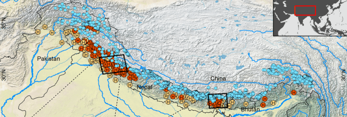
The Himalayan nations’ thirst for energy is increasing. Hydropower is among the most important energy sectors and has experienced massive growth rates during the last years. This growth is expected to further increase in the coming years. More than 400 Himalayan hydropower projects (HPP) are currently registered or at validation for the Clean Development Mechanism (CDM) alone, a global environmental investment and credit scheme to enable countries with emission-reduction commitments to implement emission-reduction projects in developing countries.
In our now published paper in Environmental Research Letters, we show that – as opportune sites along major rivers are already occupied – numerous planned or currently constructed HPP expand into river reaches higher upstream and closer to glacial lakes. These lakes, dammed behind moraines, may sporadically burst upon dam failure and create so-called glacial lake outburst floods (GLOFs). We mapped more than 2000 lakes dammed by terminal or lateral moraines along the Himalayan Arc and calculated outburst scenarios for each using a physically based dam breach model. Since many of the variables of this model are impossible to constrain from remote sensing data alone, we adopted a probabilistic approach and used a Monte-Carlo simulation to derive entire distributions of outburst scenarios. Using TopoToolbox, we determined the flow paths of potential GLOFs from each lake and used these paths as input to a 1D flood propagation model that we fed with the results of the Monte-Carlo simulation. This allowed us to track how uncertainties about lake bathymetry and dam characteristics propagate downstream, and showed that these uncertainties remain significant, for most lakes, until a distance of 80 km downstream. This is the distance within which more and more HPPs are planned or currently constructed.
Clearly, our approach is based on a series of assumptions and limitations, and I encourage you to read the full paper (open access) for a detailed discussion of these. We conclude that the current massive expansion of HPP closer to glaciated areas entails that our lack of knowledge about the stability and geometry of glacial lakes will make it increasingly difficult to estimate potential flood magnitudes and thus compromise reliable risk assessment and safety planning of new HPP projects.
Schwanghart, W., Worni, R., Huggel, C., Stoffel, M., Korup, O. (2016): Uncertainty in the Himalayan energy-water nexus: estimating regional exposure to glacial lake outburst floods. Environmental Research Letters, 11, 074005. [DOI: 10.1088/1748-9326/11/7/074005]
- ← Previous
- 1
- 2
- 3
- 4
- Next →
